
14-06-2007 10:21 | Estofex | m.b.t. 14-06-2007 t/m 15-06-2007
Storm Forecast
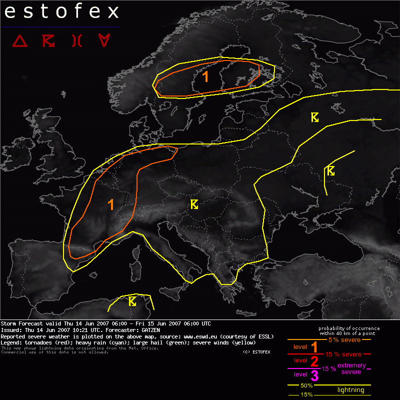
Valid: Thu 14 Jun 2007 06:00 to Fri 15 Jun 2007 06:00 UTC
Issued: Thu 14 Jun 2007 10:21
Forecaster: GATZEN
SYNOPSIS
South-westerly flow increases over western Europe, with a jet axis from Portugal to the Baltic Sea and western Russia. Two jet streaks are located east of the main trough centers to the west of Bay of Biscay and over western Scandinavia. The former jet streak extends into a broad delta flow regime over Europe. An embedded short-wave trough now located over Germany will spread north-eastward during the day crossing the Baltic Sea region, while a strong jet streak develops at its eastern flank.
Warm and unstable air mass is present over most of Europe south-east of the jet stream. Latest soundings indicate steep low-level lapse rates from France to Germany, Alpine region, Italy, Balkans, Greece, as well as from Ukraine to western Russia. Especially over the Mediterranean Sea and western Europe, low-level moisture has increased, and instability is expected to develop over a broad area.
DISCUSSION
Eastern France, Benelux, western, and northwestern Germany
Ahead of the mentioned trough center, a jet streak evades into Bay of Biscay and Iberian Peninsula during the day, spreading into western Mediterranean and France until FRI morning. Associated cold front is expected to move across most of France during the period. Ahead of the cold front, strong WAA is expected. Latest soundings indicate warm air mass over west Europe, where latest soundings indicate an EML and only weak instability. This air mass will likely destabilize due to height falls ahead of approaching jet streak. Additionally, a convergence zone is forecast to develop ahead of the cold front underneath the axis of the WAA regime, and low-level moisture convergence is likely. Surface dewpoints are already in the 15-17°C range. Latest satellite images indicate that strong diabatic heating is likely over eastern France today, and GFS is quite reasonable showing CAPE values up to 1500 J/kg late in the day. Limiting factor is rather cool boundary layer, and associated capping inversion.
However, strong low-level forcing along the convergence line as well as outflow-boundaries from actual convection over central France will likely be sufficient for initiation during the afternoon hours. Given some deep layer vertical wind shear around 15 m/s, expect that convection will organize into mesoscale convective systems moving northeastward in the evening hours. Although vertical wind shear is not too strong, locally favorable veering may be sufficient for mesocyclones.
Main severe threat will be severe wind gusts along the leading edge of the systems, but isolated large or very large hail as well as tornadoes are not ruled out, especially associated with isolated mesocyclones that may develop east of the main convective system in the WAA regime. Decide to issue a level 1 due to uncertainties of instability as well as limited vertical wind shear during the day. An upgrade to level 2 may be warranted when strong instability will develop indeed and low-level southerly winds will increase over eastern France, creating stronger vertical wind shear.
Additional convection is expected to develop further north where low-level air mass is unstable and WAA is also expected throughout the period. Thunderstorms that form will have a potential to produce strong wind gusts and isolated large hail due to steep low-level lapse rates, moderate DLS, and locally favorable low-level wind shear especially in the range of outflow-boundaries.
Given persisting QG forcing in the WAA regime, thunderstorms may also merge into MCSs moving ENE-ward into northwestern Germany during the evening, where well-developed low-level convergence is expected south of the strong frontal boundary over the coastal region. Severe wind gusts are expected to be the main threat, but a slight chance for brief tornadoes is also expected, as low-level wind shear can be quite strong.
During the night hours, expect that a couple of MCS will propagate northeastward over eastern France, western Alps, western Germany, and Benelux. Best potential exists over western France/western Alps, where latest model guidance indicates increasing LLJ feeding the system throughout the night. Severe wind gusts are forecast to be the main threat, but isolated large hail and tornadoes in association with embedded supercells are not ruled out. In the morning hours, weakening instability is expected, and convective systems are forecast to weaken.
Central Scandinavia, Baltic Sea
Strong QG forcing over Baltic Sea region is expected during the day, where potential for severe thunderstorms is forecast. Latest satellite image indicates a convective line that has formed over central Sweden. Given strong vertical wind shear and linear forcing, potential for bowing lines is rather high during the next hours. Later in the period, the convective line is forecast to move into rather dry low-level air mass over the Baltic Sea region. Increasing linear forcing and strong vertical wind shear as well as increasing potential for cold pool formation may be sufficient to keep the system alive, that may cross the Baltic Sea moving into southern Finland in the evening/night hours. Strong vertical wind shear is forecast ahead of the system, as well as favorable veering. Expect that slight chance for severe wind gusts will remain along the strongly-forced convective line, while tornadoes along the leading edge are not ruled out completely due to strong veering profiles. Limiting factor will be quite dry low-levels.
Most of eastern, and south-eastern Europe
Steep lapse rates, rather weak vertical wind shear, and high coverage of storms initiating along old outflow-boundaries, are expected during the period. Although chance for severe weather is rather limited, do not exclude a couple of large hail and severe wind gust reports. Even brief tornadoes are not ruled out in the range of old outflow-boundaries. While there's no focus of expected severe convective potential, and density of expected reports is very low, a risk level is not issued.
Hagel(-schade) | Onweer/blikseminslag | Tornado/hoosverschijnsel(en) | Verwachtingen/waarschuwingen | Wind/storm (-schade)
