
04-08-2021 22:41 | Estofex | m.b.t. 05-08-2021 t/m 06-08-2021
Storm Forecast
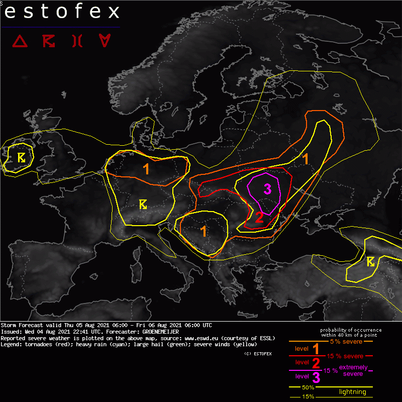
Valid: Thu 05 Aug 2021 06:00 to Fri 06 Aug 2021 06:00 UTC
Issued: Wed 04 Aug 2021 22:41
Forecaster: GROENEMEIJER
A level 3 was issued across Ukraine for all hazards including strong tornadoes, severe wind gusts, large or very large hail, and very heavy rainfall.
A level 2 was issued across a large area including parts of Romania, Moldova, Ukraine, Slovakia, and Poland. Across Poland, Slovakia, NW Ukraine, and Romania, very heavy rainfall is an important hazard. Across all but southern Poland and Slovakia, large hail, severe winds, and tornadoes are important hazards.
A level 1 was issued for parts of the Ukraine and Russia mainly for isolated large hail and to a lesser extent for severe wind and heavy rainfall.
A level 1 was issued across the Central and Western Balkans and the Pannonian Plain, mainly for isolated large hail and locally very heavy rainfall.
A level 1 was issued across Northwest Poland, North Germany, and the Netherlands for local, heavy rainfall.
+ + + A tornado outbreak is forecast across Ukraine, Moldove and Northeast Romania + + +
SYNOPSIS
An intense shortwave trough initially over the Adriatic Sea tracks east-northeastward to reach Belarus Friday morning. Pressure falls ahead of it lead to a deepening surface cyclone that will move from Hungary to eastern Poland.
DISCUSSION
NW Poland, North Germany, Netherlands...
Slow-moving showers with locally heavy downpours exceeding 40 mm in 1-2 hours are locally possible, warranting a level 1. In addition, some marginally large (2-3 cm) hail is possible.
(alleen de voor NL en aangrenzende gebieden relevante tekstdelen overgenomen, klik hier voor de volledige forecast, red.)
Verwachtingen/waarschuwingen | Wateroverlast/(zware) neerslag
