
22-06-2016 23:55 | Estofex | m.b.t. 22-06-2016 t/m 23-06-2016
Storm Forecast
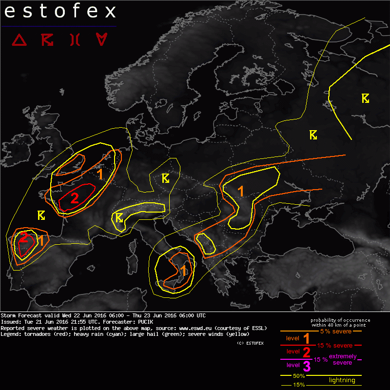
Valid: Wed 22 Jun 2016 06:00 to Thu 23 Jun 2016 06:00 UTC
Issued: Tue 21 Jun 2016 21:55
Forecaster: PUCIK
A level 2 was issued for NW France mainly for large to very large hail, severe wind gusts and to the lesser extent for excessive precipitation and tornadoes.
A level 1 was issued for extreme N France, SE England, Belgium and Netherlands mainly for severe wind gusts, excessive precipitation and to the lesser extent for large hail.
A level 1 was issued for S Italy mainly for marginally large hail.
A level 1 was issued for W Balkans through Romania into Ukraine mainly for large hail, severe wind gusts and excessive precipitation.
SYNOPSIS
With several days of extremely severe thunderstorm activity over parts of E Europe, situation will finally begin to ease off over this region. Primary reason will be the weakening of mid-tropospheric flow as trough over Central Europe fills up, coincident with a decrease in the DLS. Northern part of the trough will continue moving eastwards, along with the cold front, across W Russia. A cut-off low will remain almost stationary just to the SW of Sicily. A change in the pattern is forecast over W Europe with an amplifying trough over the Atlantic. SW-ly flow will advect a plume of steep lapse rates over moist airmass over W and Central France.
Several areas, both in W and E Europe require closer inspection with enhanced probability of severe weather.
DISCUSSION
... NW France ...
All models agree on the increase in the low-level moisture over the area while already at Tuesday 21 UTC, surface observations reveal dewpoints up to 18 deg C. In conjuction with the steepening lapse rates from the south, moderate CAPE values are forecast over the area (1000 - 2000 J/kg). Strengthening mid and upper tropospheric flow will yield high values of DLS (20 - 30 m/s), so that very well organised convection can be anticipated. Supercell convection will be also supported by an increase in SRH as surface flow backs to easterly with low pressure south of the area. Forecast soundings display favourable veering of winds with height and by 18 UTC, 200 - 400 m2/s2 of SRH is forecast in the 0-3 km layer especially in the NW part of the Lvl 2. Parallel mid to upper tropospheric flow to the boundary suggest that storms may have tendency to cluster, but any storm that manages to stay out of the boundary could remain in the form of isolated supercell, capable of large to very large hail. A brief window will exist in the evening also for tornadoes as boundary layer stabilizes but low level shear ramps up. It is likely that storms progress along the boundary in the form of a cluster or small MCS in the night hours towards NE, being capable of severe wind gusts and/or excessive precipitation. Detrimental factor, especially across the northern parts of the Lvl 2 may be lingering cloudiness.
... Belgium, Netherlands, SE England ...
Lower CAPE values forecast for this area decrease the overal risk of severe weather. Nevertheless, if some storms manage to initiate during the day, they may become supercells with a threat of marginally large hail due to the strong vertical wind shear. Region may be also impacted during the night hours by the convective clusters (or MCS) moving in from France. Such system would pose predominantly a risk of severe wind gust or an excessive rain event.
(alleen de voor NL en aangrenzende gebieden relevante tekstdelen overgenomen, klik hier voor de volledige forecast, red.)
Hagel(-schade) | Onweer/blikseminslag | Verwachtingen/waarschuwingen | Wateroverlast/(zware) neerslag | Wind/storm (-schade)
