
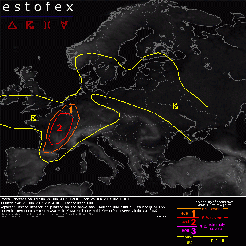
Storm Forecast Valid: Sun 24 Jun 2007 06:00 to Mon 25 Jun 2007 06:00 UTC
23-06-2007 | Estofex | m.b.t. 24-06-2007 t/m 25-06-2007
Level-1 over o.a. uiterst ZZO-NL i.v.m. kans op tornado's
Storm Forecast
Valid: Sun 24 Jun 2007 06:00 to Mon 25 Jun 2007 06:00 UTC
Issued: Sat 23 Jun 2007 20:24
Forecaster: DAHL
SYNOPSIS
An intense upper trough is expected to slowly cross the British Isles during the period. A weak upper vort max located northwest of Iberia on Saturday evening will merge with this large-scale trough and move across France and Germany into east-central Europe until Monday morning. Intensifying SFC low is accompanying the large-scale trough, resulting in low-level warm/moist advection especially over France. Ample westerly upper flow will continue to exist over the northern Mediterranean and eastern Europe, though slight upper ridging will affect these areas. Impressive EML remains in place atop quite moist boundary-layer air over much of the Mediterranean.
DISCUSSION
... France ... southern Benelux countries ...
It seems that at least portions of the EML will make it across the southeastern half of France on Sunday. Some uncertainty exists on the boundary-layer moisture, but it seems that dewpoints will increase at least somewhat, so that maximum afternoon MLCAPEs may be on the order of 1000 to 1500 J/kg.
Shear profiles are expected to be quite strong with 500 hPa winds of 20 to 25 m/s and about 10 m/s at 850 hPa. Strong forcing for upward motion will be provided by the DCVA-regime ahead of the small vort max crossing central Europe during the period as well as along the surface cold front.
Current thinking is that thunderstorms will initiate along and ahead of the cold front over central France in the afternoon hours. It seems that the dominant severe mode will vary along the front. Towards the south, where the EML is anticipated to be present, main threats seem to be large hail and damaging winds while towards the north, with weaker capping, the tornado threat will increase. Still, an isolated tornado or two may also occur over the southern portions of France given generally favorable LLS.
Tornado/hoosverschijnsel(en) | Verwachtingen/waarschuwingen