19/02/2026 - (niet aangemeld)

Nieuws

Periode:
tm
Bron:
Tag/type:

<<<87/122>>>

Storm Forecast valid: Fri 01 Jun 2018 07:00 to Sat 02 Jun 2018 06:00UTC
01-06-2018 - Estofex | m.b.t. 01-06-2018 t/m 02-06-2018
A level 1 is issued for parts of Belgium, France, SW Germany, parts of England and Ireland mainly for excessive convective precipitation.
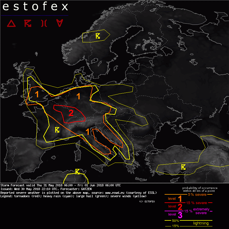
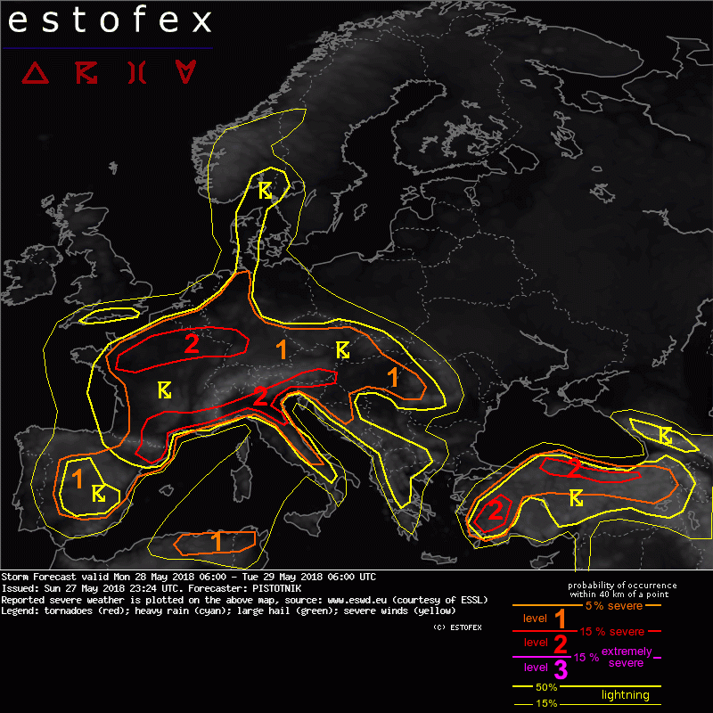
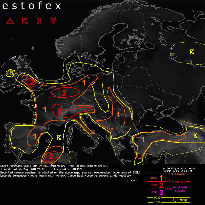
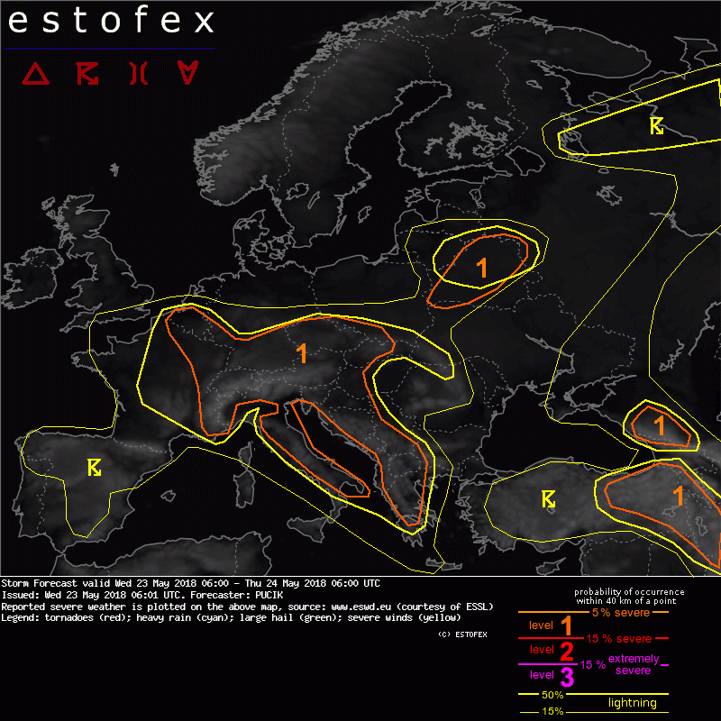
Storm Forecast valid: Thu 31 May 2018 06:00 to Fri 01 Jun 2018 06:00UTC
30-05-2018 - Estofex | m.b.t. 31-05-2018 t/m 01-06-2018
A level 1 was issued across the southern British Isles, Benelux, most of Germany, Czech Republic, northern and western Balkans, and Italy mainly for excessive precipitation.
RP ONLINE User-Videos: So heftig tobte das Unwetter über NRW
30-05-2018 - YouTube | m.b.t. 30-05-2018
(Youtube Video)
Code oranje voor onweersbuien op 29 mei 2018
30-05-2018 - KNMI | m.b.t. 29-05-2018
Overlast en schade door water, hagel en wind.
Mesoscale Discussion Valid Tue 29 May 2018 14:00 to Tue 29 May 2018 20:00UTC
29-05-2018 - Estofex | m.b.t. 29-05-2018
Netherlands, Northwest Germany, North Belgium... Scattered convection is quickly expanding in coverage. Within an area of surface wind convergence and low pressure, across which the ingredients for flash floods are in place.
Storm Forecast valid: Tue 29 May 2018 06:00 to Wed 30 May 2018 06:00UTC
28-05-2018 - Estofex | m.b.t. 29-05-2018 t/m 30-05-2018
A level 2 was issued across NE-France and Benelux to Germany and the W-Czech Republic mainly for excessive rain. A level 1 surrounds the level 2 for lower/more localized excessive rainfall instances. Otherwise, isolated large hail, an isolated tornado event and a few severe wind gusts are possible.
Storm Forecast valid: Mon 28 May 2018 06:00 to Tue 29 May 2018 06:00UTC
27-05-2018 - Estofex | m.b.t. 28-05-2018 t/m 29-05-2018
A level 1 and level 2 are issued for a large region between NE Spain (Catalonia), Germany, W Romania and Italy for excessive convective precipitation and large hail.
Storm Forecast valid Sun 27 May 2018 06:00 to Mon 28 May 2018 06:00UTC
26-05-2018 - Estofex | m.b.t. 27-05-2018 t/m 28-05-2018
A level 2 was issued across parts of Belgium, Luxembourg and CNTRL-Germany mainly for excessive rain. A level 1 surrounds the level 2 areas with similar hazards but lower probabilities. In addition a few severe wind gust and large hail events are possible and an isolated tornado event over S-UK can't be excluded.
Storm Forecast valid: Wed 23 May 2018 06:00 to Thu 24 May 2018 06:00UTC
23-05-2018 - Estofex | m.b.t. 23-05-2018 t/m 24-05-2018
A level 1 was issued across much of Central Europe, Italy and western Balkans mainly for excessive precipitation and large hail. (de lvl-1 area omvat nog juist het uiterste zuiden van Limburg en de NL/B grensstreken, red.)
Storm Forecast valid: Tue 22 May 2018 06:00 to Wed 23 May 2018 06:00UTC
21-05-2018 - Estofex | m.b.t. 22-05-2018 t/m 23-05-2018
A level 1 covers a large part of Europe mainly for excessive precipitation and large hail and to a lesser extent severe convective wind gusts.
Bij toeval windsnelheid gemeten in Tornado Viersen (223 km/u)
17-05-2018 - Weerwoord | m.b.t. 16-05-2018
Bericht op het Weerwoord forum. Wat een toeval en door onderzoek ter plaatse geverifieerd!
Grote hagel +/- 3 tot 3,5 cm gezien te Krefeld (Dld)
16-05-2018 - Weerwoord | m.b.t. 16-05-2018
Bericht op Weerwoord-forum met beeldmateriaal. (bevat ook een verwijzing naar de tornado in de omgeving van Viersen Dld, red.)

<<<87/122>>>