
23-05-2018 06:01 | Estofex | m.b.t. 23-05-2018 t/m 24-05-2018
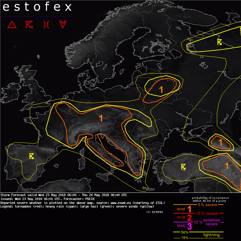
Storm Forecast
Valid: Wed 23 May 2018 06:00 to Thu 24 May 2018 06:00 UTC
Issued: Wed 23 May 2018 06:01
Forecaster: PUCIK
A level 1 was issued across much of Central Europe, Italy and western Balkans mainly for excessive precipitation and large hail.
SYNOPSIS
As of Wednesday morning, satellite imagery reveals several short-wave troughs / small-scale lows at mid to upper troposphere over Europe. The first one is located west of Iberian coastline moving slowly SE-wards during the day. Another one will reside over NW France, slowly moving W-ward during the forecast period. A short-wave is also crossing Belarus and to the south, a short-wave will move NE-wards from S Italy towards Balkans, already associated with thunderstorm activity in the morning hours.
Generally speaking, much of W / Central / SE Europe is under the pool of lower geopotentials, in rather weak prevailing flow. Combined with warm and modestly moist airmass in the lower troposphere, and lapse rates of around 6 to 6.5 K/km in the lower to mid-troposphere, scattered to widespread convection is forecast across a large part of the continent.
DISCUSSION
... E France to W Balkans ...
12 UTC soundings from the previous day show weakly sheared environment with skinny CAPE profiles and relatively high RH throughout the low and mid troposphere. Model output shows no significant change in conditions for today. Local boundaries, topography and differential heating of surface will act as triggers in the uncapped airmass. Poorly organized convection is forecast, with multicell clusters being the prevalent convective type. Due to the slow storm movement and moist profiles, heavy precipitation will be the dominant threat. Isolated large hail may occur with stronger cells. While the threat of heavy rainfall is elevated over the whole broad area, the highest threat will be confined to W Balkans coastline, Croatia, W Hungary and E Austria, where the most abundant lower level moisture is forecast. Convergent winds also suggest increased heavy rainfall threat over N France / S Belgium.
(alleen de voor NL en aangrenzende gebieden relevante tekstdelen overgenomen; klik hier voor de volledige forecast, red.)
Hagel(-schade) | Verwachtingen/waarschuwingen | Wateroverlast/(zware) neerslag
