
26-05-2018 20:02 | Estofex | m.b.t. 27-05-2018 t/m 28-05-2018
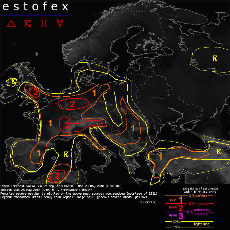
Storm Forecast
Valid: Sun 27 May 2018 06:00 to Mon 28 May 2018 06:00 UTC
Issued: Sat 26 May 2018 20:02
Forecaster: TUSCHY
A level 2 was issued across parts of France, S-Switzerland, S-Austria and N-Italy mainly for excessive rain.
A level 2 was issued across parts of Belgium, Luxembourg and CNTRL-Germany mainly for excessive rain.
A level 2 was issued across parts of S-UK mainly for excessive rain.
A level 1 surrounds the level 2 areas with similar hazards but lower probabilities. In addition a few severe wind gust and large hail events are possible and an isolated tornado event over S-UK can't be excluded.
A level 2 was issued for N-Algeria mainly for large to very large hail, excessive rain and severe wind gusts.
A level 1 was issued for S-Poland to the CNTRL-Balkan States mainly for excessive rain and isolated large hail.
A level 1 was issued for parts of Turkey mainly for excessive rain and isolated large hail.
SYNOPSIS
Ongoing blocking pattern over Europe results in another active thunderstorm day. This pattern is featured by a substantial upper trough over W-Europe, which is composed of numerous smaller-scale vortices. One vortex just W of the Normandy re-strengthens during the forecast as another impulse from the W merges with that vortex. Another vortex over N-Germany/Denmark weakens/opens up and shifts to the NW over the North Sea. This configuration supports a merging of a SE-ward migrating anticyclone over S-Scandinavia with ridging over the CNTRL-Mediterranean downstream of the aforementioned upper trough. This setup assists in an ongoing advection of a warm/moist and unstable air mass from the Mediterranean towards CNTRL-Europe.
Downstream of that ridge, another upper trough affects far SE-Turkey. CAA occurs east of the Scandinavian high with 850 hPa temperature dropping to below zero.
No well defined synoptic-scale fronts are forecast, so faint mid-level impulses (circling the W-European trough), orography and mesoscale convergence zones dictate the coverage of thunderstorm activity during this forecast. One exeption is a maturing/deforming warm front over S-UK to CNTRL-Germany, which transforms into a wavy and quasi-stationary boundary. This zone with strong LL confluence serves as main focus for more widespread CI.
DISCUSSION
... S-UK, Belgium, Luxembourg, France, S-Alps and N-Italy ...
Areas W/NW of the W-Alps see numerous convergence zones with LL mixing ratios in excess of 10 g/kg. A dominant one becomes established from S-UK to CNTRL-Germany (see SYNOPSIS). Northward fanning EML downstream of the W-European trough overlaps with that rich BL moisture and despite a weakening trend of mid-level lapse rates (partially due to convective overturning from the previous day) robust MLCAPE is forecast in most areas. The majority of models agrees in a broad swath with 1-1.5 kJ/kg MLCAPE while some CAMs indicate even higher values along pronounced convergence zones. A similar moisture/lapse rate setup exists along/S of the Alps/over N-Italy resulting in an analog CAPE magnitude.
An fly in the ointment is ongoing shower/thunderstorm activity from the previous night over S-UK, Benelux/W-Germany to SE-France during the morning hours. This could temper diabatic heating and CAPE magnitude a bit on a regional scale. However most models agree in robust CI with this activity as the environmental CAPE increases during the day.
With weakening mid-level ridging aloft, DLS is meager at best with values in general below 10 m/s. Pockets with stronger mid- or upper-level winds result in regions with 15 m/s DLS or 1-8 km shear (e.g. CNTRL-Germany and S-UK). Enhanced LL flow exists over S-UK with some weakening betimes as the pressure gradient starts to relax. Nevertheless, augmented 0-1km shear and SRH-1 is forecast in that area.
This environment supports robust updraft development during the day with CI linked to diabatic heating, orography, passing mid-level waves and the remnant of overnight convection. Slow moving and even training convection will be a major issue and serious flash flooding could occur due to clustering/slow moving thunderstorms. Over S-/CNTRL-UK, looped but small hodographs indicate a chance for training activity and despite lower CAPE, excessive rain with flash flooding is a distinct possibility. The level 2 areas were issued where ingredients point to more widespread/clustered CI with an attendant enhanced flash flood threat.
Initiating storms also pose a large hail risk despite lack of shear. Betimes, growing cold pools support upscale growth of convection and swaths of strong to severe wind gusts are possible at least on a temporal scale. Beside the rainfall risk over S-UK, some enlargement of the lower parts of the hodograph with 100 m^2/s^2 SRH-1 and LCLs of 600-1000 m also add an isolated tornado risk.
A similar risk for slow moving strong to severe convection exists over the S-Alps and a localized serious flash flood risk beneath slow moving thunderstorms exists - next to large hail. This threat translates to the S betimes and affects NW-Italy during the afternoon/evening. The level 2 was issued where growing thunderstorm tap into rich moisture and a very unstable air mass along/south of the Alps.
The level areas were expanded towards parts of SE-France with similar conditions.
Verwachtingen/waarschuwingen | Wateroverlast/(zware) neerslag
