
27-05-2018 23:24 | Estofex | m.b.t. 28-05-2018 t/m 29-05-2018
Storm Forecast
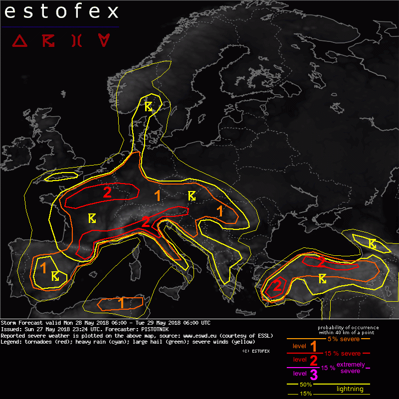
Valid: Mon 28 May 2018 06:00 to Tue 29 May 2018 06:00 UTC
Issued: Sun 27 May 2018 23:24
Forecaster: PISTOTNIK
A level 1 is issued for Spain mainly for excessive convective precipitation.
A level 1 and level 2 are issued for a large region between NE Spain (Catalonia), Germany, W Romania and Italy for excessive convective precipitation and large hail.
A level 1 and level 2 are issued for W Turkey mainly for excessive convective precipitation and to a lesser degree large hail.
A level 1 and level 2 are issued for N and E Turkey mainly for a large hail and to a lesser degree for excessive convective precipitation, severe convective wind gusts and tornadoes.
A level 1 is issued for NE Algeria and NW Tunisia mainly for large hail and to a lesser degree for severe convective wind gusts.
SYNOPSIS
Weak pressure and temperature gradients remain in places across most of Europe. The formerly Scandinavian anticyclone shifts a bit east to the Baltics and Belarus, allowing a large but shallow upper-level low over Iberia to further extend its influence towards France and central Europe. Another upper-level low is placed over Turkey, and finally a more compact but deeper one over the North Sea.
The polar jet is deflected to the far north. The subtropic jet runs across the Maghreb States.
DISCUSSION
... continental Europe (including Spain) ...
Another round of scattered to widespread, diurnally driven thunderstorms will form in the warm and moist air across much of Europe. CAPE will be confined to some hundred J/kg where convection forms early, but may reach 1000-2000 J/kg in areas of steeper lapse rates and/or delayed convective initiation, as indicated by several of Sunday's 12z sounding in central Europe. Vertical wind shear is weak with values around or below 10 m/s across the lowest 6 km. In terms of synoptic lift, the Spanish upper-level low sends several subtle vorticity maxima across France and the greater Alpine region, whereas synoptic lift is absent everywhere else.
Storms can bring moderately large hail in intiating stages and flash floods plus isolated cold-pool-driven severe wind gusts later on, when large clusters form. The hail risk is maximized to the N and E of larger mountains (Pyrenees, Alps, Apennines), where thermal upslope circulations beneath weak SW-erly mid-level flow may enhance vertical wind shear just enough to favor multicellular organization. Otherwise, flash floods are the dominant risk. Despite a lack of distinct convergence zones, two level 2 areas were introduced for those areas where models largely agree on widespread convective initiation under robust CAPE.
Weaker lapse rates limit CAPE magnitude over Spain, reducing the hail risk. However, partly embedded storms in vicinity of the upper-level low center could still cause a few heavy rain events, hence the level 1 was extended there.
The eastern boundary of the thunderstorm-prone area is formed by drier and slightly cooler air that infiltrates into E-central Europe, but this zone is quite diffuse. It should be noted that GFS and WRF show much more CAPE in this zone (E Germany, Poland, Slovakia, Romania) than the rest of the models. The thunder and risk level areas were drawn rather conservatively here, following the majority of the model pool and considering the presence of weak synoptic subsidence, which should reduce storm coverage even in case the higher CAPE values should yet materialize.
(alleen de voor NL en direct aangrenzende gebieden relevante tekstdelen zijn overgenomen, klik hier voor de volledige forecast, red.)
Hagel(-schade) | Onweer/blikseminslag | Verwachtingen/waarschuwingen | Wateroverlast/(zware) neerslag
