
01-06-2018 07:23 | Estofex | m.b.t. 01-06-2018 t/m 02-06-2018
Storm Forecast
Valid: Fri 01 Jun 2018 07:00 to Sat 02 Jun 2018 06:00 UTC
Issued: Fri 01 Jun 2018 07:23
Forecaster: PISTOTNIK
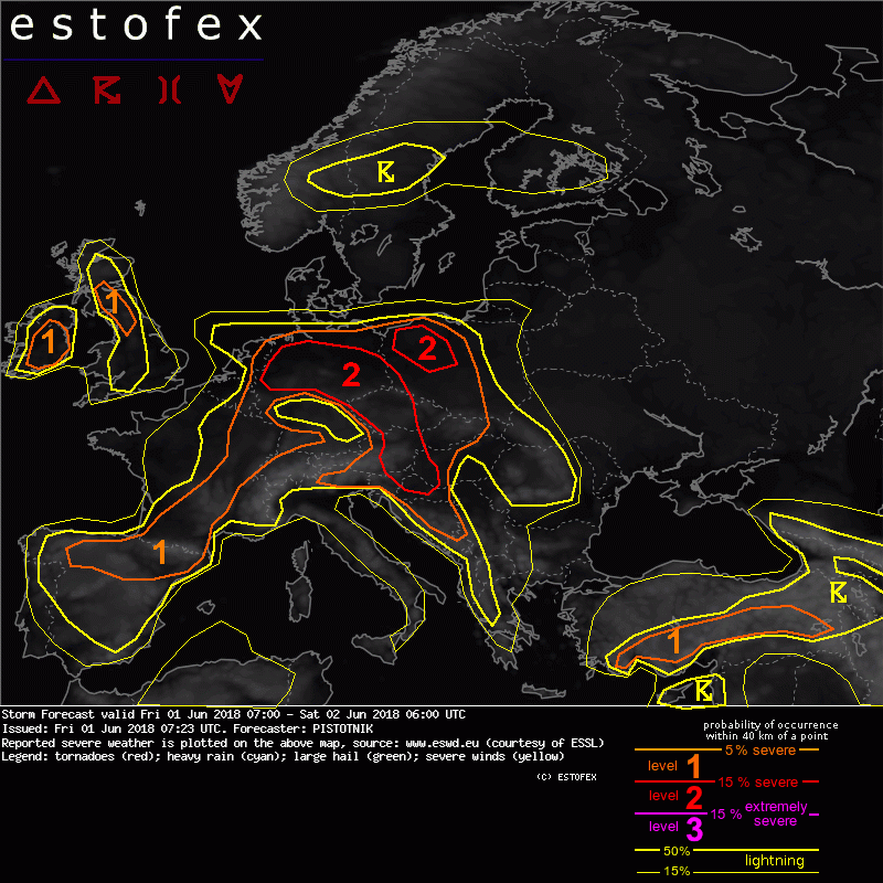
A level 2 is issued from NW Germany to E Croatia mainly for excessive convective precipitation and to a lesser degree for large hail and severe convective wind gusts.
A level 1 and level 2 are issued for parts of Poland and Slovakia, Bosnia-Herzegovina, and S to SE Turkey for excessive convective precipitation, large hail and severe convective wind gusts.
A level 1 is issued for parts of Belgium, France, SW Germany, parts of England and Ireland mainly for excessive convective precipitation.
A level 1 is issued for N Spain mainly for excessive convective precipitation and large hail.
SYNOPSIS
An ill-defined omage pattern covers the European sector. Between a deep polar trough over W Russia and cut-off lows over the north-central Atlantic and Portugal, a broad and shallow ridge stretches from the central Mediterranean region into Scandinavia. Near the surface, an anticyclone moves from Belarus into the Ukraine, while pressure gradients are weak everywhere else.
Warm and moist air remains in place across wide areas of the continent.
DISCUSSION
... Belgium, W and S Germany, Switzerland, France, Spain, Portugal, Uk, Ireland ...
Slightly cooler but still moist air is present behind the main convergence zone. Around 500 J/kg of CAPE will form after some hours of daytime heating. Scattered, disorganized afternoon storms pose a risk of isolated flash floods. Slightly enhanced deep-layer shear is present (1) beneath a further weakening jet-streak from S Germany into Belgium and (2) in N Spain ahead of the Portuguese cut-off low. Marginally large hail is not ruled out in these areas.
Particularly low cloud bases over the British Isles indicate a possibility of one or two non-supercellular tornadoes, in particular if sea breeze fronts move some distance inland.
(allen de voor NL relevante tekstdelen overgenomen, klik hier voor de volledige forecast, red.)
Verwachtingen/waarschuwingen | Wateroverlast/(zware) neerslag
