
24-04-2012 22:59 | Estofex | m.b.t. 25-04-2012 t/m 26-04-2012
Storm Forecast
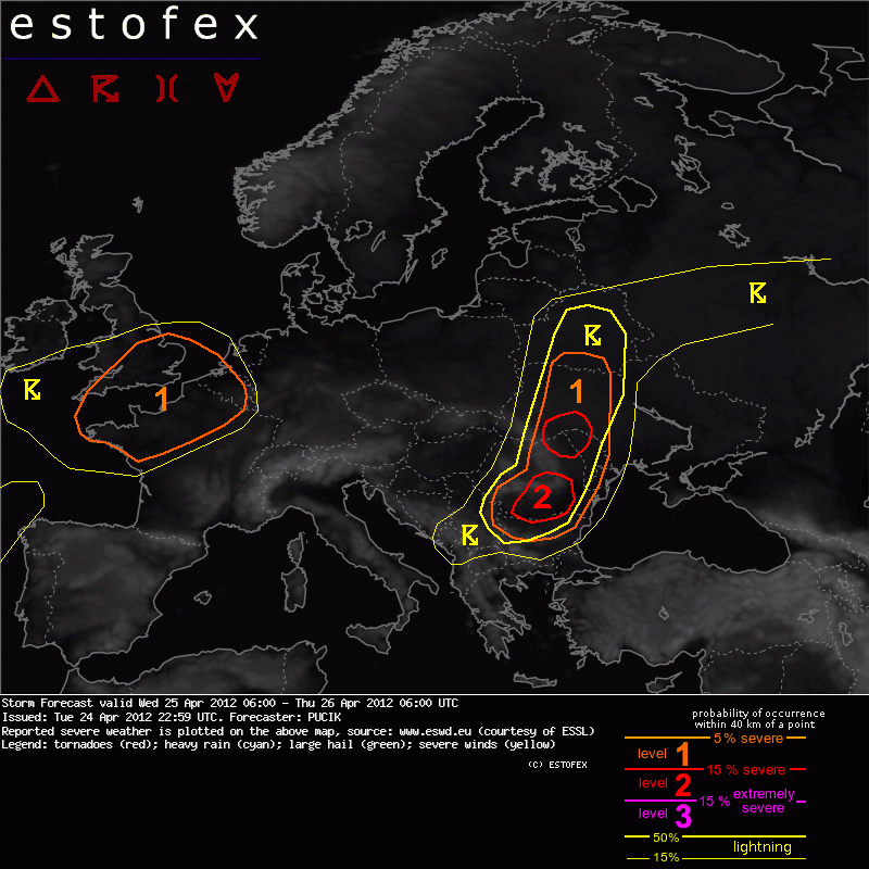
Valid: Wed 25 Apr 2012 06:00 to Thu 26 Apr 2012 06:00 UTC
Issued: Tue 24 Apr 2012 22:59
Forecaster: PUCIK
A level 1 was issued for NW France, S England and Belgium mainly for severe wind gusts and tornadoes.
A level 2 was issued for southern Romania mainly for large hail, severe wind gusts and to the lesser degree for tornadoes and excessive precipitation.
A level 2 was issued for northern Romania mainly for large hail and excessive precipitation and to the lesser degree for tornadoes and severe wind gusts.
A level 1 was issued for N Bulgaria and S to central Romania mainly for large hail, severe wind gusts and to the lesser degree or tornadoes and excessive precipitation.
A level 1 was issued for N Romania to Ukraine mainly for excessive precipitation and to the lesser degree for marginally large hail, severe wind gusts or tornadoes.
SYNOPSIS
A complex synoptic setup is forecast over Europe during the given day. Major feature will be a deep cyclonic vortex featuring very strong low level wind fields (over 30 m/s at 850 hPa level) over the eastern Atlantic, centered just south of the British Isles as of 12 UTC. Strong mid (40 m/s) and upper level (60 m/s) jet is forecast on the southern and southeastern flank of the vortex. Towards the east, a mid/upper level trough is forecast to decay into a short wave trough crossing Poland during the day and a cut-off low, which will traverse across Romania during the afternoon hours. A mid-level ridge is expected to amplify between these two features.
Closer to the surface, a main frontal zone will run from Balkans towards Belarus and the Baltic states. Along this zone, numerous separate low pressure centers will contribute to the wavy nature of the front, especially regarding northern Romania/southern Ukraine. Another frontal zone will be linked to the deep low pressure system, crossing western Europe during the day.
DISCUSSION
... NW France to S England / Belgium...
Behind the large stratiform precip shield of the warm front, in the strong southwesterly flow, models predict weakly unstable airmass, featuring almost indifferent vertical temperature gradient spreading across this region. Thanks to the very deep low, with its central pressure close to 970 hPa, intense low level wind field is forecast, with 925 to 850 hPa wind speeds approaching 35 m/s in the region of NW France and in the range of 25-30 m/s elsewhere. Forecast soundings/hodographs reveal very skinny CAPE profiles with unidirectional strong shear confined mostly to 700 hPa, with no further significant increase in windspeeds above this level. MLCAPE values should not exceed 500 J/kg, with more realistic predictions between 100-200 J/kg (per ECMWF/WRF simulations).
Deccelerating mid and upper level low, along with unfavorable position of the jet-streak during the development of instability over the region point to the reduced possibility of strong, concentrated forcing favoring rapid development of QLCS along the cold front. Nevertheless, scattered DMC is forecast, which should pose risk of severe wind gusts and tornadoes, especially thanks to the LLS exceeding 15 m/s. Threat should be the most prominent between 12-15 UTC timeframe, virtually ceasing after 18 UTC. An upgrade to Lvl 2, especially over NW France is possible if forcing or instability prove to be more favorable.
(alleen de voor NL en aangrenzende gebieden relevante tekstdelen overgenomen, klik hier voor de volledige forecast, red.)
Verwachtingen/waarschuwingen
