
24-07-2021 16:56 | Estofex | m.b.t. 25-07-2021 t/m 26-07-2021
Storm Forecast
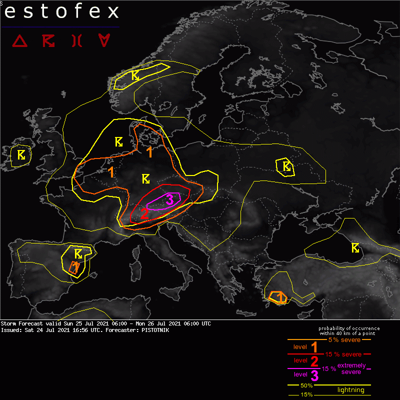
Valid: Sun 25 Jul 2021 06:00 to Mon 26 Jul 2021 06:00 UTC
Issued: Sat 24 Jul 2021 16:56
Forecaster: PISTOTNIK
A level 3 is issued for far-south Germany into N Austria for large hail and severe convective wind gusts.
A level 1 and level 2 are issued for Switzerland, SE Germany, the Czech Republic, Austria and N Italy for large hail, severe convective wind gusts and excessive convective precipitation.
A level 1 is issued for the rest of Germany mainly for excessive convective precipitation and to a lesser extent for large hail.
A level 1 is issued for SE England, N France, BeNeLux and Denmark mainly for excessive convective precipitation.
A level 1 is issued for E Spain mainly for large hail.
A level 1 is issued for SW Turkey mainly for large hail.
SYNOPSIS
The dominant feature on the weather maps is a cut-off low centered over the Channel, whose periphery spreads ober Iberia, France, Germany, Denmark and the British Isles. It is filled with moist and temperate maritime air. A compact surface low emerges from Saturday's thunderstorm activity at its forward flank over W Germany and BeNeLux and drifts offshore onto the North Sea.
Further east, pressure and temperature gradients are weak. A warm, blocking anticyclone stretches from Scandinavia to the Ukraine and SW Russia. It is flanked by a shallow cut-off low over Turkey and strong zonal flow in the far NE of our forecast domain.
The subtropic branch of the jet stream stretches from Iberia to the Alpine region before it curves towards Greece and the E Mediterranean Sea. It partly overlaps with hot, moderately to highly unstable air and sets the stage for an expected outbreak of organized, severe thunderstorms in particular in the Alpine region.
DISCUSSION
... SE England, BeNeLux, France, Germany, Denmark ...
Daytime heating creates CAPE on the order of 500-1000 J/kg under miuch weaker vertical wind shear behind the diffuse cold front. Scattered to widespread, rather low-topped convection is expected in form of single cells, multicells and poorly organized clusters. In Germany, still somewhat stronger 0-6 km shear (around 10 m/s) and slightly steeper lapse rates can promote the formation of marginally large hail or copious amounts of small hail with multicells. Otherwise and in general further west, localized excessive rainfall becomes the main risk in the moist and weakly sheared airmass. Near the center of the cyclonic low-level wind field, one or two non-supercellular tornadoes are not ruled out in N France, Belgium and SE England, in particular at sea breeze fronts (daytime) or land breeze fronts (nighttime).
Thunderstorms over land will be strongly diurnally driven, apart from N Germany and Denmark, where maximized synoptic lift will shift the center of the activity into the following night.
(alleen de voor NL en direct aangrenzende gebieden tekstdelen overgenomen, klik hier voor de volledig forecast, red.)
Verwachtingen/waarschuwingen | Wateroverlast/(zware) neerslag
