
19-10-2021 19:40 | Estofex | m.b.t. 20-10-2021 t/m 21-10-2021
Storm Forecast
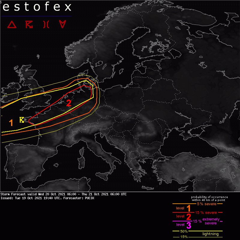
Valid: Wed 20 Oct 2021 06:00 to Thu 21 Oct 2021 06:00 UTC
Issued: Tue 19 Oct 2021 19:40
Forecaster: PUCIK
A level 2 was issued across NW France, BENELUX and NW / N Germany mainly for damaging wind gusts and tornadoes.
A level 1 was issued around the Lvl 2 mainly for damaging wind gusts and tornadoes.
SYNOPSIS and DISCUSSION
Potentially dangerous situation may evolve over NW Europe tomorrow evening and night with threat of damaging wind gusts and tornadoes!
Models agree on a sharp short-wave trough ejecting from the Atlantic and crossing W France, S UK, BENELUX and ending up over N Germany by Thursday morning. 45 - 50 m/s jet-streak embedded in the southern flank of the trough will provide ample synoptic-scale forcing ahead of it. Closer to the surface, a cold front will cross France and Germany. Warm sector ahead of the front is forecast to be marginally unstable with MLCAPE values ranging from 50 to around 200 J/kg. CAPE will be limited by modest amounts of lower tropospheric moisture.
While CAPE will stay marginal, warm sector will be very strongly sheared with 0-3 km bulk shear exceeding 25 m/s, 0-1 km bulk shear exceeding 15 m/s and 0-1 km SRH locally reaching up to 300 m2/s2. Low-topped supercells are forecast to develop with strong low-level rotation that will pose threat of tornadoes and severe wind gusts. Given the intensity of the low-level wind shear, some of the tornadoes may be strong. Any developing storm will also pose a risk of severe wind gusts given the strong background flow reaching 30 m/s at 850 hPa level.
High-resolution models currently trend more towards isolated supercells or small linear segments rather than towards large convective system. For example, ICON-D2 simulates a number of long-lived, isolated supercells with strong vertical vorticity tracks. It should also be noted that the storms will move very fast with forward speeds of 25 - 35 m/s. The first storms are expected over the UK in the morning and around the noon. The threat will rapidly increase across W France towards 18 UTC and the storms will spread owards BENELUX and Germany during the evening and night. Severe weather risk will likely persist till Thursday 06 UTC as the cold front approaches E Germany.
While some details (potentially game changing) may change tomorrow, such as how much CAPE will be available in the warm sector or the amount of curvature in hodographs, this situation will require attention from forecasters covering areas within the Lvl 1, Lvl 2 or in their immediate vicinities.
Tornado/hoosverschijnsel(en) | Verwachtingen/waarschuwingen | Wind/storm (-schade)
