
07-09-2022 07:05 | Estofex | m.b.t. 07-09-2022 t/m 08-09-2022
Storm Forecast
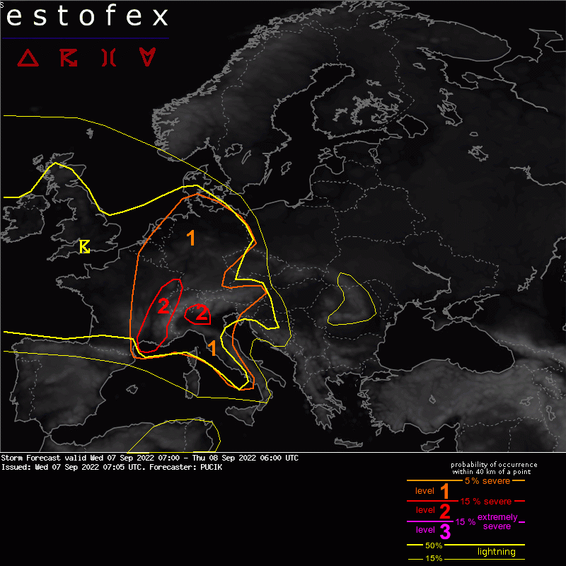
Valid: Wed 07 Sep 2022 07:00 to Thu 08 Sep 2022 06:00 UTC
Issued: Wed 07 Sep 2022 07:05
Forecaster: PUCIK
A level 2 was issued across E France mainly for large to very large hail, excessive rainfall, and severe wind gusts.
A level 2 was issued across parts of N Italy mainly for large hail, excessive rainfall, and to a lesser degree for tornadoes.
A level 1 was issued across NE France, W, and N Germany mainly for large hail, excessive rainfall, and to a lesser degree for severe wind gusts.
A level 1 was issued for the W Italy coastline mainly for excessive rainfall and large hail.
DISCUSSION
In the mid-troposphere, a deep low resides SW of Ireland. At its S flank, a short-wave trough will move from NW Iberia towards France and BENELUX. Closer to the surface, a cold front is forecast to cross France and W Germany by Thursday morning. A warm front will stretch from NE Germany through W and S Poland.
A large area of scattered to widespread thunderstorms is forecast across W and central Europe. Several areas will also see a higher potential for severe weather:
... E France into Switzerland and W Germany ...
In this region, storms are anticipated mostly in the late evening/overnight hours and will be associated with the arrival of the cold front. 0-6 km bulk shear between 15 and 20 m/s along with curved hodograph suggest a risk of supercells. That said, storms will likely be widespread with a convective system forming as the cells merge together. Severe wind gusts, large hail, and also excessive precipitation are possible with the storms.
(alleen de voor NL en direct aangrenzende gebieden relevante tekstdelen overgenomen, klik hier voor de volledige forecast, red.)
Hagel(-schade) | Verwachtingen/waarschuwingen | Wateroverlast/(zware) neerslag | Wind/storm (-schade)
