
16-09-2023 23:07 | Estofex | m.b.t. 17-09-2023 t/m 18-09-2023
Storm Forecast
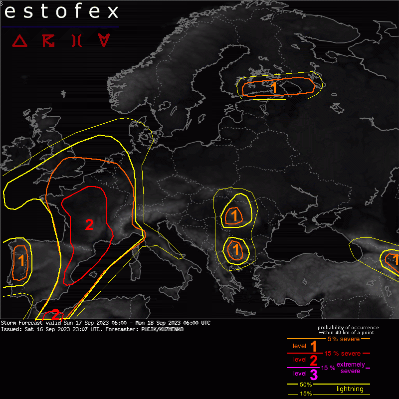
Valid: Sun 17 Sep 2023 06:00 to Mon 18 Sep 2023 06:00 UTC
Issued: Sat 16 Sep 2023 23:07
Forecaster: PUCIK/KUZMENKO
A level 2 was issued across E/NE Spain and France mainly for large to very large hail, damaging wind gusts, heavy rainfall and tornadoes.
A level 1 was issued across the S UK mainly for heavy rainfall.
A level 1 was issued across BENELUX, W Germany, Switzerland mainly for heavy rainfall and to the lesser degree for severe wind gusts or tornadoes.
SYNOPSIS
A deep trough resides over the Bay of Biscay and NW Iberia. At its forward flank, strong mid to upper tropospheric flow is forecast with 300 hPa windspeeds up to 55 m/s. Models show several short-wave troughs embedded in the jet. Two most pronounced ones will travel from France towards S UK during the day and the second will move over Iberia and reach France towards the late evening and night hours. A complex frontal boundary will run across W Europe, with warm front across the UK and the Northern Sea, while a diffuse cold front will strech across the Bay of Biscay into Spain. The cold front will move E towards the evening hours.
A particularly sharp-short wave trough will cross Finland and reach Russia in the late afternoon hours, associated with a surface cold front. Further S, a wak trough will reside over Romania and Bulgaria and a low will cover S Russia at mid-troposphere.
DISCUSSION
... France ...
Scattered elevated storms are forecast to be present across NW France during the start of the forecast period in the WAA regime. Further storms will develop during the afternoon and evening hours and will spread E and SEward. Convective initiation will occur along the cold front, the convergence zones and the upslope flow towards the Pyrenees or Massif Central. Strong vertical wind shear will be present across the whole France with 0-6 km bulk shear between 20 and 30 m/s. CAPE will increase from E to W and from N to S. The threat of very large hail will be highest N of Pyrenees and near Massif Central. In the late evening hours, upscale growth into linear segments with severe wind gusts will be possible. All models show an increase in low-level shear towards 18 UTC, increasing the tornado risk basically over the whole region. This particularly concerns the Massif Central storms, where the low-level shear will be the strongest with strongly curved hodographs and 0-500 m SRH locally over 150 m2/s2. The storms may become elevated towards the later night hours with threat shifting towards the heavy rainfall and storms spreading towards the SE France coastline.
... England ...
Scattered to widespread storms are forecast across the area. Forecast soundings show poor lapse rates in the lower troposphere with little to no CAPE in the bottom 1 to 2 km. Current thinking is that majority of storms will be elevated and pose a threat of heavy rainfall in the environment of almost saturated troposphere.
... BENELUX, W Germany, Switzerland ...
Storms are forecast to reach these areas only during the night, reducing the chance for surface-based convection and thus also the risks of severe wind gusts and tornadoes, despite rather strong shear in the lower troposphere. At the very least, an isolated risk of heavy rainfall will be still present.
(alleen de voor NL en direct aangrenzende gebieden relevante tekstdelen overgenomen, klik hier voor de volledige forecast, red.)
Tornado/hoosverschijnsel(en) | Verwachtingen/waarschuwingen | Wateroverlast/(zware) neerslag | Wind/storm (-schade)
