
30-03-2024 23:03 | Estofex | m.b.t. 31-03-2024 t/m 01-04-2024
Storm Forecast
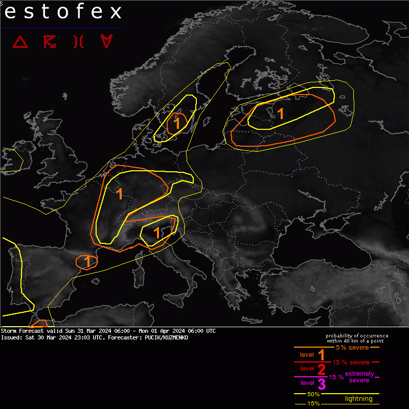
Valid: Sun 31 Mar 2024 06:00 to Mon 01 Apr 2024 06:00 UTC
Issued: Sat 30 Mar 2024 23:03
Forecaster: PUCIK/KUZMENKO
A level 1 was issued across NE Spain mainly for tornadoes and severe wind gusts.
A level 1 was issued across S-central France to BENELUX and W Germany mainly for tornadoes and severe wind gusts.
A level 1 was issued for SW and central Germany mainly for large hail and severe wind gusts.
A level 1 was issued for the Alps mainly for heavy rainfall.
A level 1 was issued across N/NE Italy mainly for severe wind gusts, tornadoes and to the lesser degree for large hail.
A level 1 was issued across S Sweden mainly for large hail and heavy rainfall.
A level 1 was issued across Lithuania, Latvia, Estonia, N Belarus and W Russia mainly for large hail, severe wind gusts and tornadoes.
A level 1 was issued across Morocco mainly for severe wind gusts and tornadoes.
DISCUSSION
IMPORTANT: A dense dust situation is currently affecting large parts of Europe. The areas experiencing dust should count on reduced solar insolation and overall lower temperature maxima compared to the model forecasts. In such case, the models will overestimate CAPE and underestimate CIN.
... central France to BENELUX and NW Germany ...
A pronounced left exit region of a jet will cross the area during the day. In conjunction, a trough in the lower troposphere will develop with an enhanced low-level wind field ahead of it. Isolated to scattered storms will initiate near the trough and spread N. Model soundings show limited CAPE with low LCLs. Hodographs show strong low-level shear with 0-1 km bulk shear exceeding 10 m/s and 0-500 m SRH locally exceeding 100 m2/s2. ICON-D2 ensemble simulates a number of swaths with high vorticity in the lower levels, suggestive of strong rotation and potential for tornadogenesis. Besides tornadoes, severe wind gusts may also occur.
... central Germany ...
While the synoptic influence will be the same here, the environment for the storms will be different, featuring steeper lapse rates and more abundant CAPE. Deep-layer shear will support both short linear segments and supercells; primary threats will be large hail and severe wind gusts. Storms will spread NE during the day and diminish in the evening.
(alleen de voor NL en direct aangrenzende gebieden relevante tekstdelen overgenomen, klik hier voor de volledige forecast, red.)
Onweer/blikseminslag | Tornado/hoosverschijnsel(en) | Verwachtingen/waarschuwingen | Wind/storm (-schade)
