
02-04-2024 20:48 | Estofex | m.b.t. 04-04-2024 t/m 05-04-2024
Extended Forecast
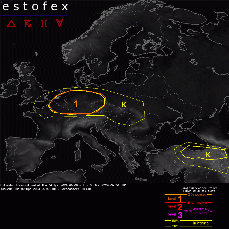
Valid: Thu 04 Apr 2024 06:00 to Fri 05 Apr 2024 06:00 UTC
Issued: Tue 02 Apr 2024 20:48
Forecaster: TUSCHY
A level 1 was issued for parts of CNTRL Europe mainly for severe wind gusts and a few tornadoes including a potential strong event. Isolated large hail is another but more isolated risk.
SYNOPTIC DISCUSSION
Positive geopotential height anomalies atop the Mediterranean face a consolidating longwave trough W of Europe. Numerous low-amplitude waves eject out of this feature with one strong impulse traversing most parts of CNTRL Europe from W to E while filling. During the forcast period a blocking subtropical ridge builds N over S-CNTRL Europe.
Another wave crosses SE Europe with a sheared appearance. In response to rising heights to the W, this wave begins to amplify over SE Europe but probably not yet in our forecast range. This wave will bring some DMC activity over N Turkey with a few hail and severe wind gust events forecast (for now not yet worth a level 1 upgrade).
NWP guidance indicates a rather stable appearance of the wave crossing N France/Benelux and Germany during the daytime hours albeit some geometric uncertainties exist like amplitude and timing. Overall confidence is high for this feature to affect the level 1 area during that period with adequate kinematic and thermodynamic input for organized convection. A LL depression could accompany this passing trough but rather broad ensemble spread of any vortex center keeps confidence in any development on the lower-end side.
DISCUSSION
... Level 1 ...
This will be the main area of concern as a passing wave with a mid/upper-level thermal trough crosses this area eastward. A diffuse LL depression could evolve over Benelux/NW Germany around noon and this features will push a rather diffuse mid-level cold front E/SE well into Germany before stalling somewhere over S-Germany. This feature is not present at all at lower levels with persistent SW-erly near BL flow and also frontogenesis remains weak at best along this boundary.
With a building ridge to the SW, a supergeostrophic upper jet maximum with NW-erlies noses into this area of interest with strong mid-level westerly flow along the tip of the wave affecting most of the level 1 area. All this combined offers an impressive kinematic setup over all of the level 1 area both in directional and speed shear.
Forecast soundings indicate adequate CAPE for healthy updrafts in addition to low LCLs in the sub-600 m range. Discrete to semi-discrete convection is forecast with some line-ups along any convergent BL flow regime. Also, some convective lines are possible betimes with growing cold pools. Any DMC activity will be accompanied by strong to severe wind gusts and a few hail events.
The tornado threat is present everywhere in this level 1 but two areas of enhanced concern exist right now. One extends from Belgium/Luxembourg into W-CNTRL Germany where more discrete convection is forecast before a more widespread upscale growth occurs (increasing the gust risk into E-Germany) and the second area extends from extreme NE France into S-CNTRL Germany, where very favorable hodographs overlap with enhanced BL moisture and maturing cells. A strong tornado event is certainly possible. Also, convective lines have to be monitored closely for a few spin-ups with ongoing favorable shear. Diminishing CAPE during the evening hours should also help to mitigate the overall severe risk.
Hagel(-schade) | Onweer/blikseminslag | Tornado/hoosverschijnsel(en) | Verwachtingen/waarschuwingen | Wind/storm (-schade)
