
04-04-2024 22:02 | Estofex | m.b.t. 05-04-2024 t/m 06-04-2024

Storm Forecast
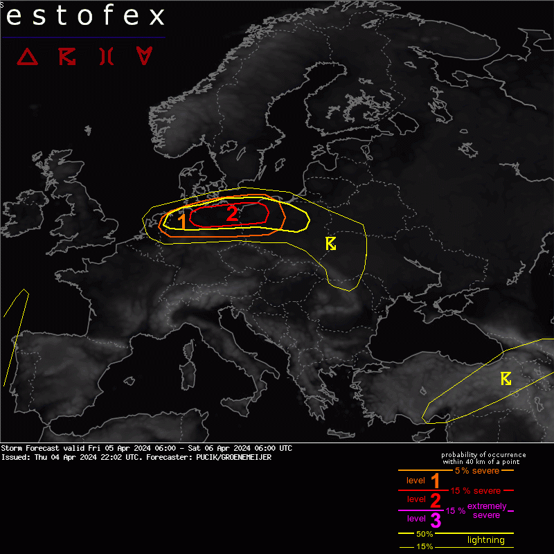
Valid: Fri 05 Apr 2024 06:00 to Sat 06 Apr 2024 06:00 UTC
Issued: Thu 04 Apr 2024 22:02
Forecaster: PUCIK/GROENEMEIJER
A level 2 was issued across N Germany and NW Poland mainly for (strong) tornadoes and damaging wind gusts
A level 1 was issued in a belt from Netherlands to Poland mainly for tornadoes and severe wind gusts.
DISCUSSION
... Netherlands to Poland ...
Yet another situation with a fast-moving and low-amplitude short-wave trough is forecast. This time, the trough will pass further noth as a ridge amplifies from the Mediterranean. Strong synoptic-scale forcing is forecast ahead of the trough, again resulting in a stratiform rain shield. Within the trough, mid-tropospheric lapse rates of up to 7K/km will allow for several hundreds J/kg of MLCAPE. Storms will be initiated by a weak cold front. CAPE will be concentrated close to the ground and forecast soundings show low LCLs.
Compared to yesterday, more impressive kinematic environment is forecast. All models show strongly curved hodographs with 0-6 km bulk shear over 30 m/s, 0-1 km bulk shear over 20 m/s and 0-500 m SRH exceeding 250 m2/s2. Combined with 850 hPa flow reaching 25 m/s, the environment will support strongly rotating supercells and bow echoes with a risk of tornadoes. Given the high-end low level shear, a strong tornado or two will be possible. Besides, the bow echoes will bear a risk of damaging wind gusts.
High resolution convection allowing models and their ensembles show scattered supercells rapidly moving east. As the storms move towards Poland, line segments and bow echoes may also form. High values of vertical vorticity near the surface along the track of simulated storms reinforce our confidence in a high tornadic potential of this situation. Lvl 2 is introduced where the highest confidence exists in the potential track of tornadic supercells. Severe weather risk will decrease after 21 UTC with reduction in the surface-based CAPE as storms move from west to central Poland.
Onweer/blikseminslag | Tornado/hoosverschijnsel(en) | Verwachtingen/waarschuwingen | Wind/storm (-schade)
