
14-04-2024 20:24 | Estofex | m.b.t. 14-04-2024 t/m 15-04-2024
Storm Forecast
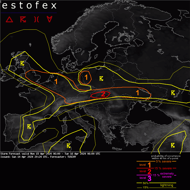
Valid: Mon 15 Apr 2024 06:00 to Tue 16 Apr 2024 06:00 UTC
Issued: Sun 14 Apr 2024 20:24
Forecaster: TUSCHY
A level 2 was issued for severe to damaging wind gusts across parts of S Slovakia/far N Hungary.
A level 1 was issued across SE UK into CNTRL Germany mainly for severe wind gusts and an isolated hail/tornado risk.
A level 1 was issued from the SE Germany/the Alps east into the Ukraine for swaths of large hail, severe wind gusts and an isolated tornado risk.
SYNOPSIS
Weak background momentum out of the subtropics and enhanced momentum along the midlatitudes (including a positive Arctic Oscillation) all support an ongoing low-latitude blocking event with positive height anomalies extending over most of S Europe. Two cut-offs meander deep in the south (in the 25-30N range) but play only an indirect/advective role for the European weather (e.g. backing the previous heat anomaly over most of S/CNTRL into E Europe).
Lower height anomalies over Scandinavia/S of Iceland face this belt of subtropical ridge and cause an extensive and anomalous intense upper jet configuration which runs from Ireland to Germany to Belarus.
Two depressions become the main foci for some convective activity with one moving from Scotland to N-Germany and a second one leaving Finland to the NE. Both features modulate an extensive frontal boundary over Europe as cold air ushers in from the NW into CNTRL and E Europe. Anomalous warm conditions continue along the Medierranean Sea and into SE Europe.
IFS-ENS clustering is tight with the vortex which approaches N-Germany. MSLP reading will be in the 990-995 hPa range with not much NWP shift in latest 6 runs (ICON/IFS and GFS). This LL vortex evolves along the exit region of a 3 sigma+ upper jet and works with impressive dynamics, whereas the NE European vortex decouples from the dynamic frontal zone with no further intensification forecast.
DISCUSSION
...Benelux into Germany ...
A very dynamic cold front passage is forecast during the daytime hours, which affects Benelux during the early afternoon and Germany thereafter.
Dynamics and kinematics are impressive with some weak prefrontal MUCAPE forecast especially from Benlux into W-CNTRL Germany. With forecast 0-3 km wind field, strong to severe wind gusts will be the main hazard with this frontal passage.
Regarding a QLCS tornado risk some signals arise from Belgium, Luxembourg into W-CNTRL Germany. There, 50 to 60 kt 0-3km shear vectors turn a bit more favorable regarding line orientation with strongest postfrontal pressure rise and placed just beneath the exit of an intense upper jet. However, prefrontal MUCAPE remains on the low-end side with drier prefrontal BL airmass and marginal moisture surge ahead of the front. An isolated embedded tornado event along forward racing surges is forecast - same for an isolated hail event with strongest storms.
Postfrontal convection flares up beneath cooling mid-levels with numerous thunderstorms forecast mainly from the Netherlands into far W/NW Germany. Uncapped and weakly unstable, those storms also have a chance to rotate with improving hodograph structures. Hail, strong to severe wind gusts and an isolated tornado are all possible. However, weakening diabatic heating works against this risk.
(Alleen de voor NL en direct aangrenzende gebieden relevante tekstdelen overgenomen, klik hier voor de volledige forecast, red.)
Hagel(-schade) | Onweer/blikseminslag | Tornado/hoosverschijnsel(en) | Verwachtingen/waarschuwingen | Wind/storm (-schade)
