
06-06-2016 12:00 | Estofex | m.b.t. 06-06-2016 t/m 07-06-2016
Storm Forecast
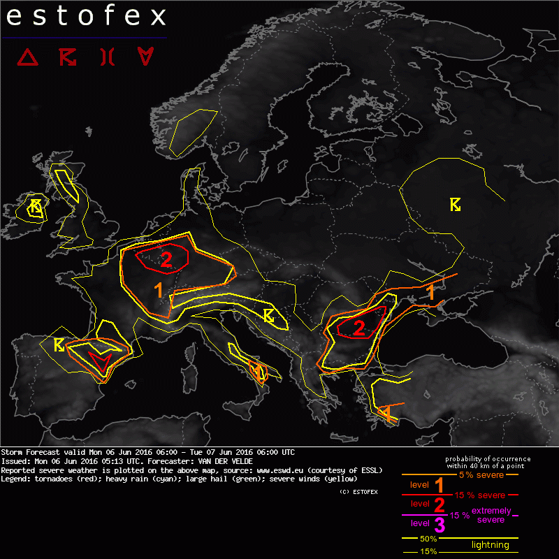
Valid: Mon 06 Jun 2016 06:00 to Tue 07 Jun 2016 06:00 UTC
Issued: Mon 06 Jun 2016 05:13
Forecaster: VAN DER VELDE
A level 2 was issued for the N France, Belgium, Luxembourg, W Germany area mainly for combined chances of excessive precipitation, severe wind gusts and large hail.
A level 2 was issued for NE Spain mainly for large hail.
A level 2 was issued for SE Romania mainly for severe wind gusts and large hail.
A level 1 was issued for Bulgaria mainly for isolated excessive precipitation.
A level 1 was issued for S Turkey mainly for large hail.
A level 1 was issued for NE France mainly for excessive precipitation.
A level 1 was issued for S Germany to Netherlands mainly for large hail and severe wind gusts.
A level 1 was issued for S Italy maily for large hail.
SYNOPSIS
A mid level blocking high pressure ridge is centered at NW Germany. It keeps large scale troughs away over the Atlantic and over Russia/Ukraine/Romania. A shortwave trough extending from the Atlantic will be able to pass over N Spain. At the surface level, high pressure is over North Sea and Baltic Sea. Thermal low pressure over the Germany-France-Benelux region accumulates 1000-1500 J/kg MLCAPE thanks to 10-11 g/kg mixing ratios under moderate mid level lapse rates. The air is most humid over France and drier in the mid levels over Germany. The unstable air is replaced by cool dry air flowing southward from Poland. Belarus, Ukraine. It focuses unstable air mass over the eastern Balkan along the cold front stretching between S Romania and S Russia.
A large part of western and central Europe have very small hodographs, resulting in slow cell motion and pulse storm mode, although clustering is locally possible.
Stronger shear is present in unstable conditions over N Spain, S Italy and S Turkey, as well as S Romania, Moldova into Ukraine, allowing supercell storm mode.
DISCUSSION
...Germany, France, Belgium, SE Netherlands area...
The main threat with slow, weakly sheared (<5 m/s 0-6 km) storms is local excessive precipitation, especially where cloud bases are lower i.e. in France, while isolated severe wind gusts and large hail are also likely in the region given the moderate MLCAPE and drier mid level air with stronger lapse rates, expressed as delta-Theta-E > 15K as well as somewhat higher cloud bases (LCL >1200m) from Netherlands to Austria.
CIN is quite weak and most storms would form in convergence lines like GFS 18Z predicts over W Germany. A level 2 was drawn for >15% combined chances of severe wind / hail / rain events where GFS optimizes CAPE, convergence, lapse rates and a PV band.
(alleen de voor NL en aangrenzende gebieden relevante tekstdelen overgenomen, klik hier voor de volledige forecast, red.)
Hagel(-schade) | Onweer/blikseminslag | Verwachtingen/waarschuwingen | Wateroverlast/(zware) neerslag | Wind/storm (-schade)
