
06-06-2016 19:40 | Estofex | m.b.t. 07-06-2016 t/m 08-06-2016
Storm Forecast
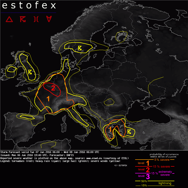
Valid: Tue 07 Jun 2016 06:00 to Wed 08 Jun 2016 06:00 UTC
Issued: Mon 06 Jun 2016 19:40
Forecaster: DAFIS
A level 2 was issued for parts of Belgium, Luxembourg, France and Germany mainly for excessive rain and large hail.
A level 1 surrounds the level 2 area and it was issued for excessive rain, large hail and severe wind gusts.
A level 1 was issued for Greece, S Bulgaria and NW Turkey mainly for excessive rain, severe wind gusts and large amounts of small hail.
SYNOPSIS
The omega blocking pattern in West Europe is somehow weakening during Tuesday due to several shortwave disturbances but a new, stronger ridge will be formed on Wednesday, with an axis from Iberia Peninsula to Ireland. A longwave trough is found in West Russia and on the surface, a cold and dry air mass is travelling south, towards the Balkans. An elongated cold front from SW Russia to SE Balkans travels fast towards Turkey and we expect DMC activity in NE Aegean Sea during Tuesday. A plume of moist and unstable air mass enters S Scandinavia, where pulsating storms will be driven by diurnal heating. We expect widespread thunderstorm activity and even though vertical wind shear is weak as the subtropical jet stream is placed over N Africa, very moist and unstable environments will be prone to severe weather events.
DISCUSSION
.... Belgium, Luxembourg, France and Germany ....
A very moist BL and rather steep mid-level lapse rates will result in the development of nearly 2000 J/kg of CAPE over this area, where we expect excessive rainfall events. PW values exceed 30 mm and keeping in mind the weak flow, storm cells are expected to be slow moving or stationary near the borders of the aforementioned countries, resulting in local flash floods. Within the most strong updrafts and due to high CAPE, large hail or large amounts of small hail cannot be ruled out.
.... Netherlands, Germany, Switzerland, S France and N Italy ....
Widespread storm activity over these areas will be driven by diurnal heating and even though global models forecast comparable amounts of CAPE with level 2 area, effective PW will be less especially in the southern parts of France, where we mostly expect isolated events of large hail. DLS is weak but dry mid and low tropospheric layers increase the potential of large hail and severe wind gusts as strong cold pools may form. In addition, in N Italy, high resolution models forecast high PW values, up to 35 mm and flash floods will be a threat.
(alleen de voor NL en aangrenzende gebiden relevante tekstdelen zijn overgenomen, klik hier voor de volledige forecast, red.)
Hagel(-schade) | Onweer/blikseminslag | Verwachtingen/waarschuwingen | Wateroverlast/(zware) neerslag | Wind/storm (-schade)
