
13-06-2016 06:49 | Estofex | m.b.t. 13-06-2016 t/m 14-06-2016
Storm Forecast
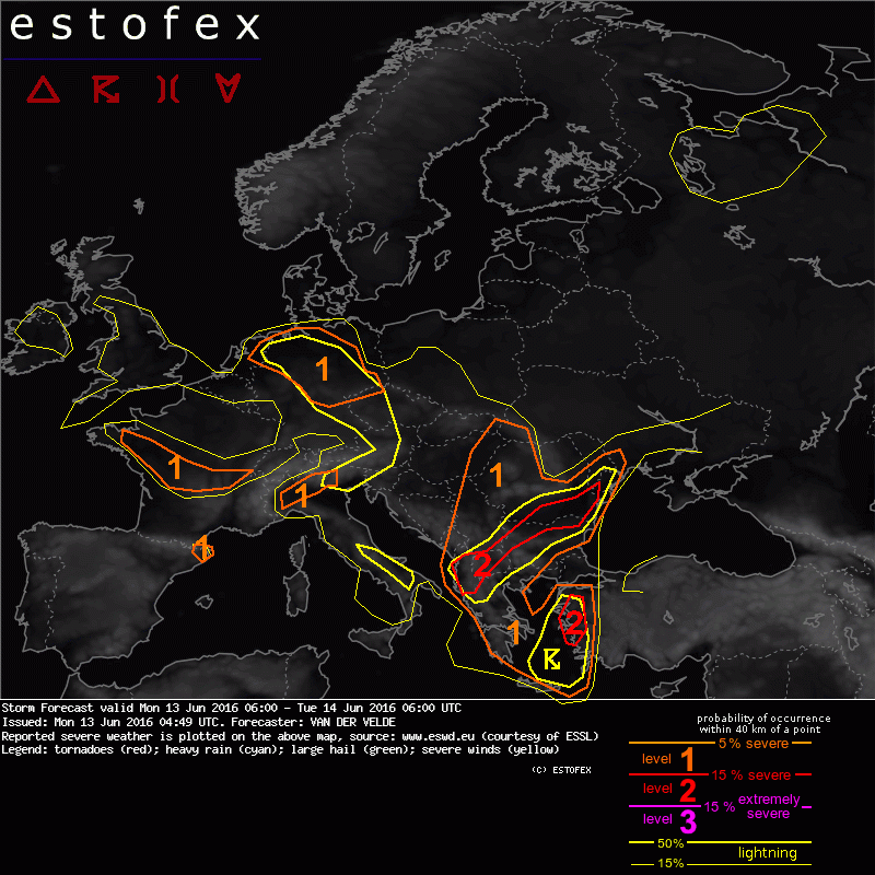
Valid: Mon 13 Jun 2016 06:00 to Tue 14 Jun 2016 06:00 UTC
Issued: Mon 13 Jun 2016 04:49
Forecaster: VAN DER VELDE
A level 2 was issued for W Turkey mainly for severe convective wind gusts and large hail as well as some tornado chances.
A level 2 was issued for Albania, FYR Macedonia, Bulgaria and SE Romania mainly for excessive convective precipitation, large hail and severe wind gusts.
A level 1 was issued for mainly for NE Netherlands and N Germany mainly for excessive convective precipitation.
A level 1 was issued for W and C France mainly for a chance of isolated tornadoes.
A level 1 was issued for N Italy mainly for isolated large hail.
A level 1 was issued for NE Catalonia/Spain mainly for isolated large hail.
A level 1 was issued for E Hungary, W Romania and Serbia mainly for excessive convective precipitation.
A level 1 was issued for Greece and W Turkey mainly for severe convective wind gusts and large hail.
SYNOPSIS
A broad upper trough spans most of NW, C and SE Europe. A chain of low pressure circulation centers near the surface stretches from Ireland, E UK, N Netherlands, W Poland, Slovakia and Romania, causing convergence of unstable air and triggering of slow-moving thunderstorms. The main upper trough passes over southeastern Europe, but there is a lack of frontal gradients and a rather incoherent pattern of PV, although a shortwave trough can be distinguished moving from S Italy to Albania, Bulgaria and Romania, where the largest CAPE values can be found in Europe today. Another passes from S Greece into W Turkey by 00Z. An Atlantic shortwave trough rapidly moves into W France during the morning, accompanied by advection of moist low-level air. The northwesterly jet stream creates large hodographs over the southern half of France, NW Italy and NE Spain, with also good low-level shear.
Large hodographs also are found under the WSW-ly jet over S Greece and Turkey. Somewhat enhanced shear will be present over SW UK and central Ireland. Rather benign shear and storm motion vectors are found through most of the rest of Europe, which can lead to excessive convective rainfall cases.
DISCUSSION
...W to C France...
For 15Z GFS and some WRF models predict slight MLCAPE and convective precipitation on the wave feature entering France from the Atlantic. It is a plume of warm low-level air and convergence zone with a mid level cold front creating a zone with both conditional and potential instability. With the upper vorticity advection this should destabilize and trigger some storms. The 20 m/s 0-6 km shear and some SREH can help mesocyclone formation in convective cells, and there is potential for tornadoes given moderate 8-12 m/s 0-1 km shear.
...N Germany area...
An old upper vortex stagnates over this region, and convergence between westerly and easterly winds takes place in a zone max a few hundred km wide. The low LCLs indicate a humid airmass, although in absolute humidity less than the past week. Very slow storm motion and weak shear make excessive precipitation the main threat, but also landspout-type tornadoes may occur as result of spin-up within sfc vorticity centers. 00Z soundings in the region show very saturated neutral profiles but quite cool air mass, which limits the PW content.
(alleen de voor NL en aangrenzende gebieden relevante tekstdelen overgenomen, klik hier voor de volledige forecast, red.)
Onweer/blikseminslag | Verwachtingen/waarschuwingen | Wateroverlast/(zware) neerslag
