
16-06-2016 12:00 | Estofex | m.b.t. 17-06-2016 t/m 18-06-2016
Storm Forecast
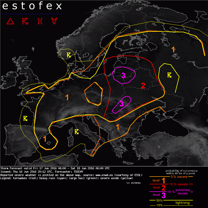
Valid: Fri 17 Jun 2016 06:00 to Sat 18 Jun 2016 06:00 UTC
Issued: Thu 16 Jun 2016 20:12
Forecaster: TUSCHY
A level 3 was issued for E-Hungary, W-Romania to SW-Ukraine mainly for damaging hail and severe wind gusts.
A level 2 surrounds that level 3 for a lesser risk of extreme events. Still large/very large hail, severe wind gusts, excessive rain and an isolated tornado event are possible.
A level 3 was issued for W-Belarus, NE Poland and Lithuania mainly for an augmented tornado risk (a significant event is possible), damaging wind gusts, large or very large hail and excessive rain.
A level 2 surrounds that level 3 for a lesser risk of extreme events. Still large/very large hail, severe wind gusts, excessive rain and an isolated tornado event are possible.
A level 1 surrounds all other level areas. All kind of severe is possible, but no extreme events are forecast.
A level 1 was issued for S-Germany mainly for isolated large hail and an isolated tornado event.
A level 1 was issued for N/W-Germany, Benelux, parts of France and S-UK mainly for excessive rain and an isolated tornado event.
A level 1 was issued for the Balearic Islands and NE Spain mainly for large hail and excessive rain. An isolated tornado event is possible.
A level 1 was issued for far W-Russia mainly for large hail and excessive rainfall amounts.
... SYNOPSIS ...
Positive tilted upper trough remains anchored over W-/CNTRL- and N-Europe. A significant impulse evolves along its eastern fringe over the Czech Republic/far E-Germany and Poland. This vortex deepens rapidly along a pronounced baroclinic zone while moving to the N/NE. On the one hand, northeastbound surging tongue of high IPV values indicates the substantial dynamics, which accompany that process, on the other hand they highlight a pronounced dry slot, which works its way from the Czech Republich over Poland to the NE.
Accompanied LL-vortex features a strong deepening rate for this time of year with surface pressure falling to 995 - 990 hPa. Phase diagrams feature transformation towards a shallow warm-core vortex, which reflects an healthy looking wrap-around occlusion. This occlusion advects a warm/moist and rather unstable air mass to the depression's center. A blend of different models places the depression over N/NW Poland at 12 UTC and over the CNTRL Baltic Sea during peak strength around 00 UTC. There, models diverge regarding further timing and track during its approach towards Finland. Reasoning probably is growing uncertainty how fast this vortex becomes vertically stacked. Until then, models in general show a unique picture with EZMW a tad slower compared to the German model suite.
Regarding fronts, the aforementioned depression pushes a sharpening warm front from Belarus to Estonia with a pronounced cold front surging over NE Poland to the E/NE. Betimes, the warm sector shrinks and the occlusion becomes the main boundary, which affects Finland.
Trailing cold front opens out into a wavy boundary, which runs from the W-Ukraine all the way to S-CNTRL Italy. An older front (already occluded for most parts) extends from N-Finland to the White Sea to W-Russia and features no substantial eastbound motion during the forecast. Regions like CNTRL/W-Europe continue to be affected by weak pressure gradients, where numerous mesoscale boundaries once again act as foci for CI.
A dangerous outbreak of severe thunderstorms is forecast over parts of E-CNTRL Europe which includes large and damaging hail, severe wind gusts, flash-flood producing rain and tornadoes!
... N-France, Belgium/parts of the Netherlands to N/NW-Germany and S-UK ...
Ageostrophic response to the deepening LL vortex to the east results in a pronounced confluent flow regime over the area of interest (mainly N-Germany). Complexity increases as a few models develop a second circulation over Benelux, which would result in another convergence zone from N-France to NW-Germany. Similar to the previous days, forecast soundings show very moist profiles with elongated/thin CAPE profiles and very low LCLs but also augmented LL lapse rates (mainly diabatically driven) with substantial LLCAPE build-up. Hence another round of slow moving and gradually clustering thunderstorms is forecast to evolve during the forenoon hours. Those clusters leisurely spread east and excessive rain is likely. Also, aforementioned favorable LL CAPE forecast and augmented 0-2 km convergence signals indicate enhanced probabilities for another round of a few funnel/isolated tornado reports.
(Alleen de voor NL en aangrenzende gebieden relevante tekstdelen overgenomen, klik hier voor de volledige forecast, red.)
Onweer/blikseminslag | Tornado/hoosverschijnsel(en) | Verwachtingen/waarschuwingen | Wateroverlast/(zware) neerslag
